Getting to Hopkins Village by Air
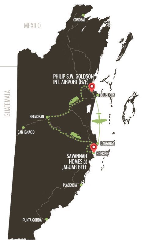
Once you fly into Philip Goldson Belize International Airport (BZE), it’s just a short 15 minute commuter flight to the Dangriga Airstrip. Hopkins is a scenic 25 minute drive from Dangriga.
To see flight schedules to and from Dangriga, please visit:
Getting to Hopkins Village by Road
Driving Directions from Philip S.W. Goldson International Airport (BZE)
Leave the airport and take a left unto the Northern Highway into the town of Ladyville.
Look for the signs to the Bermudian Landing Bamboo Sanctuary or to Burrell Boom Village.
Take a left turn off the highway towards Burrell Boom and proceed westward on the Burrell Boom road for approximately 10 miles until you exit unto the Western Highway.
Take the first right at the roundabout in Hattieville and proceed on the Western Highway towards Belmopan City.
Take a left turn off the highway into Belmopan City and proceed unto the Hummingbird Highway. Stay on this highway, past Citrus Groves and Maya Mountains, until you meet the intersection; turn right onto the Southern Highway.
You will remain on this highway for approximately 10 miles until you see the green-signed turnoff on your left. You will remain on this road for approximately 4 miles.
Upon entering the village, take the first right and drive for approximately 10 minutes until you see the entrance to Savannah Homes on your right.

Fact: The road leading into Hopkins halves the village into the Northside, affectionately known as ‘Baila’ and the Southside, also known as ‘False Sittee’.
